
File:CoalDNLBF.png
本预览的尺寸:568 × 600像素。 其他分辨率:227 × 240像素 | 454 × 480像素 | 727 × 768像素 | 1,263 × 1,334像素。
原始文件 (1,263 × 1,334像素,文件大小:844 KB,MIME类型:image/png)
摘要
| 描述 |
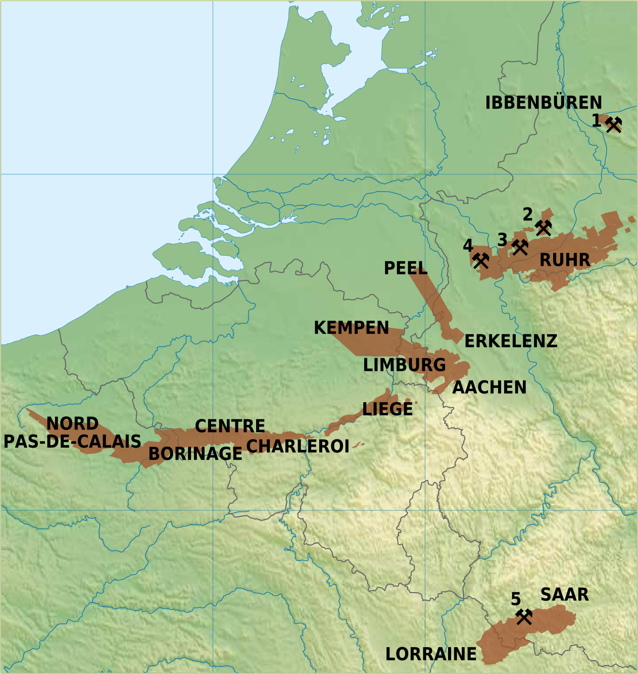
English: Overview map of coal mining areas in Belgium, Netherlands, Germany and Northern France
Nederlands: Overzicht van steenkoolmijngebieden in Belgie, Nederland, Duitsland en Noord-Frankrijk
Deutsch: Uebersichtskarte von Steinkohlrevieren in Belgien, Niederlande, Deutschland und Nord Frankreich
Français : Carte des zones de mines de charbon en Belgique, Pays-Bas, l'Allemagne et Nord de la France |
| 日期 | |
| 来源 | 自己的作品 |
| 作者 | Hans Erren |
Sources:
Germany: Ruhrkohle AG; Geologisches Landesamt Nordrhein-Westfalen, Krefeld; G Fettweis, 1953;  Ramana Rao Nunna, 1960
Netherlands: Rijks Geologische Dienst
Belgium: Kempense Steenkoolmijnen Zolder; Ministere de la Region Wallonne
France: Charbonnages de France

Active Coal Mines in 2012:
1: Bergwerk Ibbenbüren, Ibbenbüren (last coal 17 august 2018, closed 21 december 2018)
2: Zeche Auguste Viktoria, Marl (closed 18 december 2015)
3: Bergwerk Prosper-Haniel, Bottrop (closed 21 december 2018)
4: Bergwerk West, Kamp Lintfort (closed december 2012)
5: Bergwerk Saar, Saarlouis (closed june 2012)
我,本作品著作权人,特此采用以下许可协议发表本作品:
| 本文件采用知识共享署名-相同方式共享 3.0 未本地化版本许可协议授权。 | ||
| ||
| 本许可协议标签作为GFDL许可协议更新的组成部分被添加至本文件。 |
该地图是使用通用制图工具创建的: https://www.generic-mapping-tools.org/ 使用其中一个或多个公有领域浮雕数据集:
|

|
已授权您依据自由软件基金会发行的无固定段落及封面封底文字(Invariant Sections, Front-Cover Texts, and Back-Cover Texts)的GNU自由文件许可协议1.2版或任意后续版本的条款,复制、传播和/或修改本文件。该协议的副本请见“GNU Free Documentation License”。 |
您可以选择您需要的许可协议。
许可协议
我,本作品著作权人,特此采用以下许可协议发表本作品:
本文件采用知识共享署名-相同方式共享 3.0 未本地化版本许可协议授权。
- 您可以自由地:
- 共享 – 复制、发行并传播本作品
- 修改 – 改编作品
- 惟须遵守下列条件:
- 署名 – 您必须对作品进行署名,提供授权条款的链接,并说明是否对原始内容进行了更改。您可以用任何合理的方式来署名,但不得以任何方式表明许可人认可您或您的使用。
- 相同方式共享 – 如果您再混合、转换或者基于本作品进行创作,您必须以与原先许可协议相同或相兼容的许可协议分发您贡献的作品。
|
|
已授权您依据自由软件基金会发行的无固定段落及封面封底文字(Invariant Sections, Front-Cover Texts, and Back-Cover Texts)的GNU自由文件许可协议1.2版或任意后续版本的条款,复制、传播和/或修改本文件。该协议的副本请见“GNU Free Documentation License”。 |
您可以选择您需要的许可协议。
文件历史
点击某个日期/时间查看对应时刻的文件。
| 日期/时间 | 缩略图 | 大小 | 用户 | 备注 | |
|---|---|---|---|---|---|
| 当前 | 2011年1月2日 (日) 22:27 | | 1,263 × 1,334(844 KB) | Hans Erren | border cropped |
| 2011年1月2日 (日) 21:52 |  | 1,291 × 1,363(852 KB) | Hans Erren | {{Information |Description={{en|1=Overview map of coal mining areas in Belgium, Netherlands, Germany and Northern France}} {{nl|1=Overzicht van steenkoolmijngebieden in Belgie, Nederland, Duitsland en Noord-Frankrijk}} {{de|1=Uebersichtskarte von Steinkoh |
文件用途
以下页面使用本文件:
全域文件用途
以下其他wiki使用此文件:
- ar.wikipedia.org上的用途
- da.wikipedia.org上的用途
- de.wikipedia.org上的用途
- en.wikipedia.org上的用途
- fr.wikipedia.org上的用途
- li.wikipedia.org上的用途
- nl.wikipedia.org上的用途
- sr.wikipedia.org上的用途
- trv.wikipedia.org上的用途