
File:Map of England 1086.png
本预览的尺寸:479 × 599像素。 其他分辨率:192 × 240像素 | 384 × 480像素 | 614 × 768像素 | 818 × 1,024像素 | 2,398 × 3,000像素。
原始文件 (2,398 × 3,000像素,文件大小:1.43 MB,MIME类型:image/png)

|
此map图片可使用矢量图形重新创建为SVG文件。这具有很多好处;更多信息请参见共享资源:待清理媒体。如果存在此图片的SVG格式,请将其上传,然后将此模板替换为
{{vector version available|新图片名称}}。
建议您将SVG命名为“Map of England 1086.svg”,这样在使用Vector version available(或Vva)模板时就不需要填写新图片名称参数。 |
摘要
| 描述 |
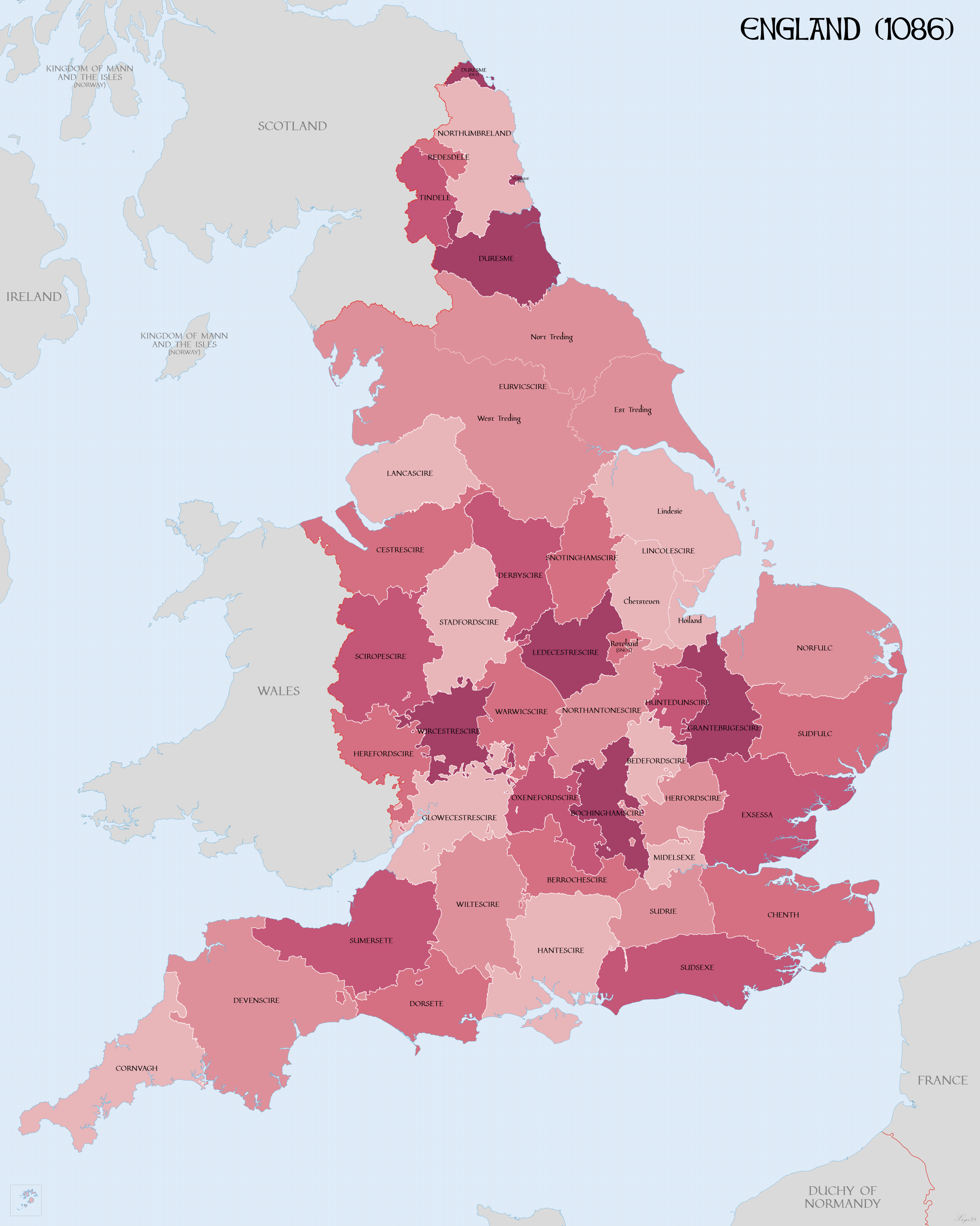
English: Map of English Counties in 1086. |
| 日期 | |
| 来源 |
个人作品,使用:
|
| 作者 | XrysD |
| 其他版本 | 此文件衍生的作品: DomesdayCountyCircuitsMap.png |
许可协议
我,本作品著作权人,特此采用以下许可协议发表本作品:
本文件采用知识共享署名-相同方式共享 4.0 国际许可协议授权。
- 您可以自由地:
- 共享 – 复制、发行并传播本作品
- 修改 – 改编作品
- 惟须遵守下列条件:
- 署名 – 您必须对作品进行署名,提供授权条款的链接,并说明是否对原始内容进行了更改。您可以用任何合理的方式来署名,但不得以任何方式表明许可人认可您或您的使用。
- 相同方式共享 – 如果您再混合、转换或者基于本作品进行创作,您必须以与原先许可协议相同或相兼容的许可协议分发您贡献的作品。
文件历史
点击某个日期/时间查看对应时刻的文件。
| 日期/时间 | 缩略图 | 大小 | 用户 | 备注 | |
|---|---|---|---|---|---|
| 当前 | 2018年4月15日 (日) 10:58 | | 2,398 × 3,000(1.43 MB) | XrysD | Increased line widths to improve clarity |
| 2018年4月14日 (六) 17:43 |  | 2,398 × 3,000(1.41 MB) | XrysD | Coastline modifcations: Lincolnshire and the Wash in accordance with "LINCOLNSHIRE COASTAL VILLAGES AND THE SEA c.1300 - c.1600: ECONOMY AND SOCIETY" Pawley (1984). Sussex: Pevensey Bay in accordance with http://saxonhistory.co.uk/. Kent: Cinque Ports area in accordance with http://www.historyfiles.co.uk/KingListsBritain/EnglandKent_Oxney01_Full.htm and http://villagenet.co.uk/history/1155-cinqueports.php. Euruicscire changed to Eurvicscire. Durham exclaves changed just to reference Durham. | |
| 2018年3月18日 (日) 09:49 |  | 2,398 × 3,000(1.46 MB) | XrysD | Added: Ridings of Yorkshire; Parts of Lincolnshire; Rutland as detached part of Notts; Norhamshire, Hexhamshire and Bedlingtonshire as parts of Durham. | |
| 2018年3月12日 (一) 18:26 |  | 2,398 × 3,000(1.45 MB) | XrysD | Changed county names uncial font to more legible version | |
| 2018年3月11日 (日) 20:59 |  | 2,398 × 3,000(1.16 MB) | XrysD | User created page with UploadWizard |
文件用途
以下页面使用本文件:
全域文件用途
以下其他wiki使用此文件:
- cs.wikipedia.org上的用途
- de.wikipedia.org上的用途
- en.wikipedia.org上的用途
- hr.wikipedia.org上的用途
- hu.wikipedia.org上的用途
- it.wikipedia.org上的用途
- ja.wikipedia.org上的用途
- ru.wikipedia.org上的用途
- sk.wikipedia.org上的用途