
File:NicoDitch.jpg
此为最大尺寸。
NicoDitch.jpg (640 × 480像素,文件大小:148 KB,MIME类型:image/jpeg)
摘要
| 描述 |
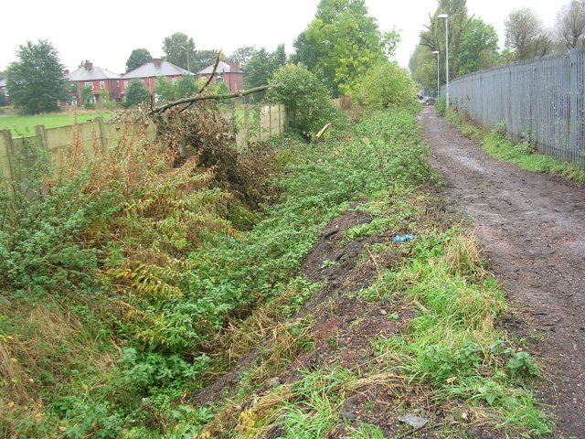
English: Nico Ditch Looking west along Nico Ditch near Levenshulme, Manchester. The public footpath seen here runs between the ditch on the left and Mellands Playing Field which lies beyond the fence on the right. About 200-300 metres of the ditch survive here and little elsewhere. This ditch is believed to have been a defensive earthwork dug in a single night as protection against the Danish invasion of 869-870 AD. It varied in width and depth, but averaged between 2 and 2.5 metres deep, and extended for over five miles in length between marshes in Fallowfield and Audenshaw. SJ88249487. |
| 日期 | |
| 来源 | From geograph.org.uk |
| 作者 | Keith Williamson |
| 署名 (由许可协议要求) | Keith Williamson / Nico Ditch / |
| 相机位置 | | 在以下服务上查看本图像和附近其他图像: OpenStreetMap |
|---|
许可协议

|
本图像来自Geograph工程图集。摄影师的联系信息请见Geograph网站上该照片的页面。本图像的著作权人为Keith Williamson,采用知识共享“署名-相同方式共享 2.0”许可协议授权二次使用。
|
本文件采用知识共享署名-相同方式共享 2.0 通用许可协议授权。
署名:
Keith Williamson
- 您可以自由地:
- 共享 – 复制、发行并传播本作品
- 修改 – 改编作品
- 惟须遵守下列条件:
- 署名 – 您必须对作品进行署名,提供授权条款的链接,并说明是否对原始内容进行了更改。您可以用任何合理的方式来署名,但不得以任何方式表明许可人认可您或您的使用。
- 相同方式共享 – 如果您再混合、转换或者基于本作品进行创作,您必须以与原先许可协议相同或相兼容的许可协议分发您贡献的作品。
文件历史
点击某个日期/时间查看对应时刻的文件。
| 日期/时间 | 缩略图 | 大小 | 用户 | 备注 | |
|---|---|---|---|---|---|
| 当前 | 2007年12月15日 (六) 18:36 | | 640 × 480(148 KB) | Malleus Fatuarum | {{Information |Description=Looking west along Nico Ditch, near Levenshulme |Source=www.geograph.co.uk |Date=2007-12014 |Author=Keith Williamson |Permission= |other_versions= }} |
文件用途
以下3个页面使用本文件:
全域文件用途
以下其他wiki使用此文件:
- de.wikipedia.org上的用途
- en.wikipedia.org上的用途
- History of Manchester
- Portal:Geography/Featured article/archive
- Nico Ditch
- Portal:Greater Manchester
- Scheduled monuments in Greater Manchester
- Portal:Geography/Featured article/January, 2012
- Wikipedia:Today's featured article/November 2018
- Wikipedia:Today's featured article/November 23, 2018
- Wikipedia:Main Page history/2018 November 23
- es.wikipedia.org上的用途
- fr.wikipedia.org上的用途
- id.wikipedia.org上的用途
- la.wikipedia.org上的用途
- pt.wikipedia.org上的用途
- simple.wikipedia.org上的用途
- tn.wikipedia.org上的用途
- uz.wikipedia.org上的用途
- www.wikidata.org上的用途