
File:Irrawaddyrivermap.jpg
預覽大小:421 × 599 像素。 其他解析度:168 × 240 像素 | 337 × 480 像素 | 862 × 1,227 像素。
原始檔案 (862 × 1,227 像素,檔案大小:208 KB,MIME 類型:image/jpeg)
檔案歷史
點選某个日期/時間檢視對應時刻的檔案。
| 日期/時間 | 縮圖 | 大小 | 使用者 | 備註 | |
|---|---|---|---|---|---|
| 目前 | 2015年12月1日 (二) 00:32 | | 862 × 1,227(208 KB) | Xufanc | Myittha River |
| 2015年11月30日 (一) 08:30 |  | 862 × 1,227(208 KB) | Xufanc | Reverted to version as of 08:22, 30 November 2015 (UTC) | |
| 2015年11月30日 (一) 08:28 |  | 862 × 1,227(208 KB) | Xufanc | Reverted to version as of 08:18, 30 November 2015 (UTC) | |
| 2015年11月30日 (一) 08:25 |  | 862 × 1,227(208 KB) | Xufanc | Reverted to version as of 08:18, 30 November 2015 (UTC) | |
| 2015年11月30日 (一) 08:22 |  | 862 × 1,227(208 KB) | Xufanc | added name of tributary | |
| 2015年11月30日 (一) 08:18 |  | 862 × 1,227(208 KB) | Xufanc | added name of tributary | |
| 2014年9月24日 (三) 06:38 |  | 862 × 1,227(219 KB) | Xufanc | Corrected wrong label | |
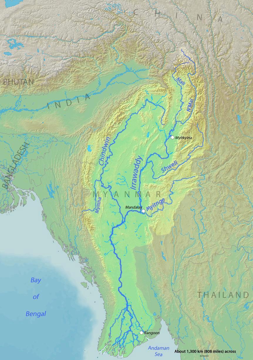
| 2010年3月3日 (三) 04:06 |  | 862 × 1,227(653 KB) | Shannon1 | {{Information |Description={{en|1=Map of the Irrawaddy River, which drains parts of Myanmar (Burma), Thailand and India into the Andaman Sea}} |Source=Background and river course data from http://www2.demis.nl/mapserver/mapper.asp |Author=[[User:Shannonc |
檔案用途
全域檔案使用狀況
以下其他wiki使用了這個檔案:
- af.wikipedia.org的使用狀況
- ar.wikipedia.org的使用狀況
- ast.wikipedia.org的使用狀況
- azb.wikipedia.org的使用狀況
- bcl.wikipedia.org的使用狀況
- be-tarask.wikipedia.org的使用狀況
- bg.wikipedia.org的使用狀況
- bh.wikipedia.org的使用狀況
- blk.wikipedia.org的使用狀況
- bn.wikipedia.org的使用狀況
- br.wikipedia.org的使用狀況
- ca.wikipedia.org的使用狀況
- cs.wikipedia.org的使用狀況
- cy.wikipedia.org的使用狀況
- de.wikipedia.org的使用狀況
- en.wikipedia.org的使用狀況
- en.wikinews.org的使用狀況
- es.wikipedia.org的使用狀況
- eu.wikipedia.org的使用狀況
- fa.wikipedia.org的使用狀況
- fr.wikipedia.org的使用狀況
- gl.wikipedia.org的使用狀況
- hif.wikipedia.org的使用狀況
- hi.wikipedia.org的使用狀況
- hr.wikipedia.org的使用狀況
- hu.wikipedia.org的使用狀況
- hy.wikipedia.org的使用狀況
- id.wikipedia.org的使用狀況
- ja.wikipedia.org的使用狀況
- ka.wikipedia.org的使用狀況
檢視此檔案的更多全域使用狀況。