
File:Colonisation 1914.png

摘要
| 描述 |
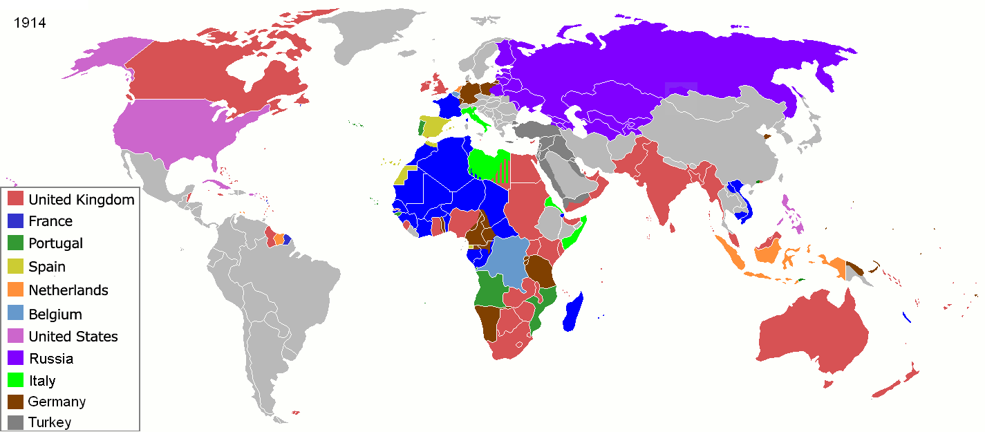
Map of major world powers by year, derived from public domain animated map on wikipedia.
As the orriginal licence of the animation was Public Domain, this image which has been derived from it is too:
|
||||||||||||||||||
| 日期 | |||||||||||||||||||
| 來源 | public domain animated map by ArdadN here | ||||||||||||||||||
| 作者 | ArdadN | ||||||||||||||||||
.jpg)
._LOC_2001620596.jpg)
授權條款

|
本圖片是以PNG、GIF或JPEG格式上傳。然而,其中包含的資料或訊息,應該重新建立成可縮放向量圖形(SVG)檔案,以更有效率或更準確的方式儲存。如有可能,請上傳本圖片的SVG格式版本。在上傳之後,請修改維基各姊妹計畫中所有使用舊版圖片的條目(列在圖像連結章節中),替換為新版圖片,並在舊圖片的描述頁中加入{{Vector version available|新圖片名稱.svg}}模板,同時移除本模板。
|
檔案歷史
點選某个日期/時間檢視對應時刻的檔案。
| 日期/時間 | 縮圖 | 大小 | 用戶 | 備註 | |
|---|---|---|---|---|---|
| 目前 | 2021年11月8日 (一) 09:07 | | 1,425 × 625(51 KB) | Randomastwritter | jubaland |
| 2020年5月15日 (五) 16:32 |  | 1,425 × 625(51 KB) | Chipmunkdavis | Freeing Belgium and Luxembourg from the Netherlands | |
| 2014年8月3日 (日) 03:05 |  | 1,425 × 625(51 KB) | Alvin Lee | Chinese-Russian boarder | |
| 2011年9月9日 (五) 00:59 |  | 1,425 × 625(50 KB) | SpencerCS | Substantial corrections to Ottoman Empire, Africa, and the Pacific | |
| 2007年3月22日 (四) 10:41 |  | 1,425 × 625(66 KB) | Roke~commonswiki | {{Information |Description=Map of major world powers by year, derived from public domain animated map on wikipedia. {{Maps of world history}} As the orriginal licence of the animation was Public Domain, this image which has been derived from it is too: { |
檔案用途
下列頁面有用到此檔案:
全域檔案使用狀況
以下其他wiki使用了這個檔案:
- ba.wikipedia.org 的使用狀況
- bn.wikipedia.org 的使用狀況
- bn.wikibooks.org 的使用狀況
- bs.wikipedia.org 的使用狀況
- ca.wikibooks.org 的使用狀況
- cs.wikipedia.org 的使用狀況
- de.wikipedia.org 的使用狀況
- en.wikipedia.org 的使用狀況
- en.wikibooks.org 的使用狀況
- es.wikipedia.org 的使用狀況
- fa.wikipedia.org 的使用狀況
- fi.wikipedia.org 的使用狀況
- fr.wikipedia.org 的使用狀況
- fr.wikiversity.org 的使用狀況
- hu.wikipedia.org 的使用狀況
- hy.wikipedia.org 的使用狀況
- it.wikipedia.org 的使用狀況
- nn.wikipedia.org 的使用狀況
- no.wikipedia.org 的使用狀況
- oc.wikipedia.org 的使用狀況
- pl.wikipedia.org 的使用狀況
- ro.wikipedia.org 的使用狀況
- ru.wikipedia.org 的使用狀況
- sk.wikipedia.org 的使用狀況
- te.wikipedia.org 的使用狀況
- uk.wikipedia.org 的使用狀況