
File:ElectoralCollege2016.svg

此 SVG 檔案的 PNG 預覽的大小:800 × 465 像素。 其他解析度:320 × 186 像素 | 640 × 372 像素 | 1,024 × 595 像素 | 1,280 × 744 像素 | 2,560 × 1,488 像素 | 1,020 × 593 像素。
原始檔案 (SVG 檔案,表面大小:1,020 × 593 像素,檔案大小:30 KB)
| U.S. presidential election maps (SVG) |
|
1788-1789 · 1792 · 1796 · 1800 · 1804 · 1808 · 1812 · 1816 · 1820 · 1824 · 1828 · 1832 · 1836 · 1840 · 1844 · 1848 · 1852 · 1856 · 1860 · 1864 · 1868 · 1872 · 1876 · 1880 · 1884 · 1888 · 1892 · 1896 · 1900 · 1904 · 1908 · 1912 · 1916 · 1920 · 1924 · 1928 · 1932 · 1936 · 1940 · 1944 · 1948 · 1952 · 1956 · 1960 · 1964 · 1968 · 1972 · 1976 · 1980 · 1984 · 1988 · 1992 · 1996 · 2000 · 2004 · 2008 · 2012 · 2016 · 2020 (Arabic) · 2024 |
| (this template: · view · discuss) |
摘要
| 描述 |
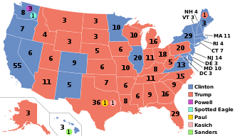
English: Electoral college map for the 2016 United States presidential election (note: Nebraska and Maine split their EVs by congressional district). |
||||
| 日期 | |||||
| 來源 | 2012 Electoral College map | ||||
| 作者 | Gage | ||||
| 其他版本 |
|
||||
| SVG開發 |

.svg)


.svg)
.svg)


授權條款
此檔案採用共享創意 姓名標示-相同方式分享 4.0 國際授權條款。
- 您可以自由:
- 分享 – 複製、發佈和傳播本作品
- 重新修改 – 創作演繹作品
- 惟需遵照下列條件:
- 姓名標示 – 您必須指名出正確的製作者,和提供授權條款的連結,以及表示是否有對內容上做出變更。您可以用任何合理的方式來行動,但不得以任何方式表明授權條款是對您許可或是由您所使用。
- 相同方式分享 – 若要根據本素材進行再混合、轉換或創作,則必須以與原作相同或相容的授權來發布您的作品。
檔案歷史
點選某个日期/時間檢視對應時刻的檔案。
| 日期/時間 | 縮圖 | 大小 | 用戶 | 備註 | |
|---|---|---|---|---|---|
| 目前 | 2025年2月27日 (四) 03:27 | | 1,020 × 593(30 KB) | Interesting 2752 | Reverted mass reversion of map to version as of 03:22, 27 November 2020 (UTC) |
| 2025年2月26日 (三) 21:11 |  | 1,020 × 593(36 KB) | Ecotto29200 | Reverted to version as of 22:50, 10 January 2017 (UTC) | |
| 2020年11月27日 (五) 03:22 |  | 1,020 × 593(30 KB) | Politicsfan4 | Updated placement of ME-2's electoral vote for consistency with 2020 map | |
| 2020年8月5日 (三) 01:22 |  | 1,020 × 593(30 KB) | Nojus R | Reverted to version as of 07:42, 13 January 2019 (UTC) it looks so weird when every other map uses a different font | |
| 2019年12月10日 (二) 19:31 |  | 1,020 × 593(30 KB) | IagoQnsi | switching font to Arial, as it looks less-ugly in the server-side rendering // Editing SVG source code using c:User:Rillke/SVGedit.js | |
| 2019年1月13日 (日) 07:42 |  | 1,020 × 593(30 KB) | Newfraferz87 | (minor) | |
| 2018年11月20日 (二) 02:50 |  | 1,020 × 593(30 KB) | Newfraferz87 | *DC | |
| 2018年11月20日 (二) 02:35 |  | 1,020 × 593(30 KB) | Newfraferz87 | Simplify further: coordinates & fills, following this | |
| 2017年1月18日 (三) 14:16 |  | 1,020 × 593(36 KB) | Newfraferz87 | Shrink size using relative line coordinates. Thanks for the border corrections. | |
| 2017年1月17日 (二) 09:20 |  | 1,020 × 593(43 KB) | Karlfk | Better borderlines, esp. OH/WV/PA triangle or ID/MT border |
.svg)
檔案用途
下列6個頁面有用到此檔案:
全域檔案使用狀況
以下其他wiki使用了這個檔案:
- af.wikipedia.org 的使用狀況
- ang.wikipedia.org 的使用狀況
- ar.wikipedia.org 的使用狀況
- الانتخابات الرئاسية الأمريكية 2016
- الانتخابات الرئاسية الأمريكية 2016 في ألاباما
- الانتخابات الرئاسية الأمريكية 2016 في تينيسي
- قالب:نتائج الولايات للانتخابات الرئاسية الأمريكية 2016
- مستخدم:Braindot4/مسيرة دونالد ترامب السياسية
- مسيرة دونالد ترمب السياسية
- تاريخ دونالد ترمب الانتخابي
- قائمة نتائج الانتخابات الرئاسية الأمريكية حسب الولاية
- arz.wikipedia.org 的使用狀況
- az.wikipedia.org 的使用狀況
- be.wikipedia.org 的使用狀況
- bg.wikipedia.org 的使用狀況
- bn.wikipedia.org 的使用狀況
- bs.wikipedia.org 的使用狀況
- ca.wikipedia.org 的使用狀況
- Donald Trump
- Plantilla Discussió:Infotaula eleccions/pre2020
- Eleccions presidencials dels Estats Units de 2016
- Plantilla:Infotaula eleccions/proves
- Plantilla:Infobox election/direct examples
- Viquipèdia:Arxivament de la Portada/Arxius/2025/05/30/02
- Viquipèdia:Arxivament de la Portada/Arxius/2025/05/30/01
- cdo.wikipedia.org 的使用狀況
- ckb.wikipedia.org 的使用狀況
- cs.wikipedia.org 的使用狀況
- cy.wikipedia.org 的使用狀況
- da.wikipedia.org 的使用狀況
- de.wikipedia.org 的使用狀況
- diq.wikipedia.org 的使用狀況
- dty.wikipedia.org 的使用狀況
- el.wikipedia.org 的使用狀況
- en.wikipedia.org 的使用狀況
- Electoral vote changes between United States presidential elections
- List of United States presidential election results by state
- Presidency of Barack Obama
- 2016 United States presidential election
- United States presidential election
- 2016 Democratic Party presidential candidates
- 2016 Democratic Party presidential primaries
檢視此檔案的更多全域使用狀況。