
File:Japanese Occupation - Map.jpg

|
File:Japanese Occupation of China 1940.svg是本檔案的向量版本。 如果品質不低,就應該優先使用該檔案,而非JPG檔案。
File:Japanese Occupation - Map.jpg → File:Japanese Occupation of China 1940.svg
更多資訊請參閱Help:SVG/zh。 |
 |
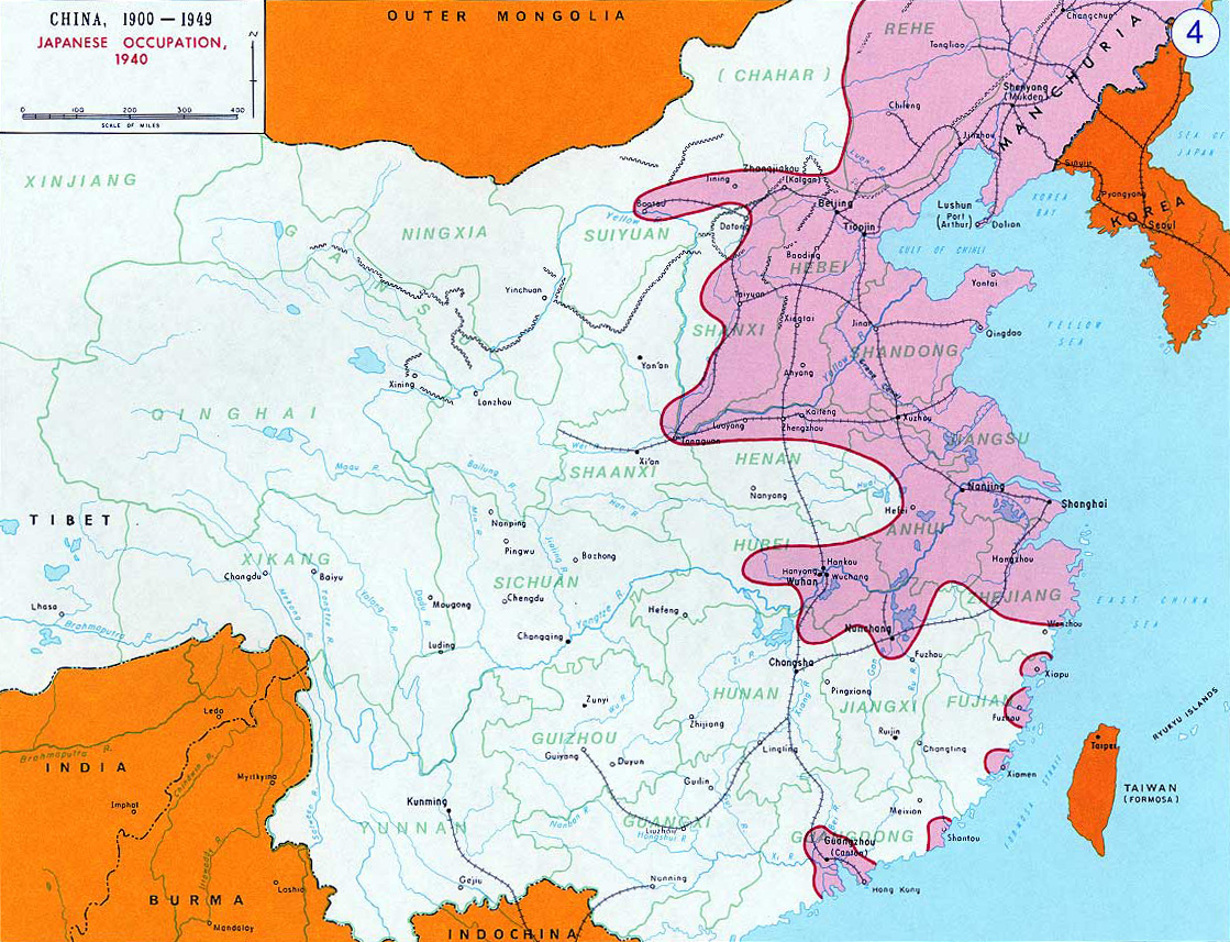
- Description: English: Japanese Occupation - 1940閩南語 / Bân-lâm-gí:Ji̍t-pún 1940-nî tī Tiong-kok tsiàm ê sóo-tsāi(hún-âng-sik).中文:中国抗日战争中,1940年日军占领区(粉紅色)。
- Source: www.dean.usma.edu archive copy at the Wayback Machine - The photo source linked here only has the photo in this low-resolution JPG format.
- Other versions: File:Second Sino-Japanese War WW2.png
- Background information:
In 1938 the predecessors of what is today The Department of History at the United States Military Academy began developing a series of campaign atlases to aid in teaching cadets a course entitled, "History of the Military Art." Since then, the Department has produced over six atlases and more than one thousand maps, encompassing not only America’s wars but global conflicts as well.
In keeping abreast with today's technology, the Department of History is providing these maps on the internet as part of the department's outreach program. The maps were created by the United States Military Academy’s Department of History and are the digital versions from the atlases printed by the United States Defense Printing Agency. We gratefully acknowledge the accomplishments of the department's former cartographer, Mr. Edward J. Krasnoborski, along with the works of our present cartographer, Mr. Frank Martini.
Please be aware that these maps are large in file size and may require substantial download times.
|
|
 |
derivative works
Derivative works of this file: OcupaciónJaponesaDeChina1940.svg
檔案歷史
點選某个日期/時間檢視對應時刻的檔案。
| 日期/時間 | 縮圖 | 大小 | 用戶 | 備註 | |
|---|---|---|---|---|---|
| 目前 | 2012年11月14日 (三) 19:17 | | 1,119 × 857(482 KB) | Mys 721tx | Reverted to version as of 22:05, 9 March 2010 Revert to larger picture. |
| 2012年11月14日 (三) 03:58 |  | 699 × 600(111 KB) | Amysze123 | ||
| 2010年3月9日 (二) 22:05 |  | 1,119 × 857(482 KB) | Ras67 | rotated and cropped | |
| 2005年6月17日 (五) 08:32 |  | 1,141 × 870(172 KB) | W.wolny |
檔案用途
下列6個頁面有用到此檔案:
全域檔案使用狀況
以下其他wiki使用了這個檔案:
- ar.wikipedia.org 的使用狀況
- be.wikipedia.org 的使用狀況
- bs.wikipedia.org 的使用狀況
- ca.wikipedia.org 的使用狀況
- cs.wikipedia.org 的使用狀況
- da.wikipedia.org 的使用狀況
- el.wikipedia.org 的使用狀況
- en.wikipedia.org 的使用狀況
- en.wikibooks.org 的使用狀況
- es.wikipedia.org 的使用狀況
- et.wikipedia.org 的使用狀況
- fi.wikipedia.org 的使用狀況
- fr.wikipedia.org 的使用狀況
- he.wikipedia.org 的使用狀況
- hr.wikipedia.org 的使用狀況
- hu.wikipedia.org 的使用狀況
- hy.wikipedia.org 的使用狀況
- it.wikipedia.org 的使用狀況
- ja.wikipedia.org 的使用狀況
- jv.wikipedia.org 的使用狀況
- kk.wikipedia.org 的使用狀況
- ko.wikipedia.org 的使用狀況
- la.wikipedia.org 的使用狀況
- lv.wikipedia.org 的使用狀況
- my.wikipedia.org 的使用狀況
- nl.wikipedia.org 的使用狀況
檢視此檔案的更多全域使用狀況。