
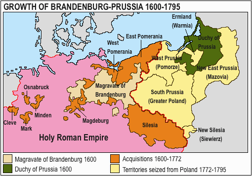
File:Acprussiamap2.gif
此為最大尺寸。
Acprussiamap2.gif (510 × 357 像素,檔案大小:27 KB,MIME 類型:image/gif、0.1秒)
檔案歷史
點選某个日期/時間檢視對應時刻的檔案。
| 日期/時間 | 縮圖 | 大小 | 使用者 | 備註 | |
|---|---|---|---|---|---|
| 目前 | 2020年3月15日 (日) 13:17 | | 510 × 357(27 KB) | E-960 | Ermland, correction. |
| 2020年3月15日 (日) 12:50 |  | 510 × 357(27 KB) | E-960 | Names of territories and format. | |
| 2009年6月1日 (一) 19:44 |  | 510 × 357(14 KB) | Hohum | Changed colours to more cartographic, less garish. Made sea blue instead of portions of land. | |
| 2006年8月25日 (五) 18:36 |  | 510 × 357(15 KB) | LeonardoG | This image was copied from wikipedia:pt. The original description was: Licença GNU, fonte en:Wikipedia. {{GFDL}} en:Image:Ac.prussiamap2.gif {| border="1" ! date/time || username || resolution || size || edit summary |---- | |} |
檔案用途
下列5個頁面有用到此檔案:
全域檔案使用狀況
以下其他wiki使用了這個檔案:
- af.wikipedia.org的使用狀況
- ar.wikipedia.org的使用狀況
- ast.wikipedia.org的使用狀況
- bg.wikipedia.org的使用狀況
- ca.wikipedia.org的使用狀況
- cs.wikipedia.org的使用狀況
- el.wikipedia.org的使用狀況
- en.wikipedia.org的使用狀況
- History of Germany
- House of Hohenzollern
- Prussia
- Margraviate of Brandenburg
- Prussian Army
- Territorial evolution of Germany
- Subdivisions of the Polish–Lithuanian territories following the partitions
- Prussian Partition
- 18th-century history of Germany
- Brandenburg–Pomeranian conflict
- Treaty of Vossem (1673)
- User:JMvanDijk/Sandbox 9/Box 15/Box 3
- User:Falcaorib/Germany and Prussia
- es.wikipedia.org的使用狀況
- et.wikipedia.org的使用狀況
- eu.wikipedia.org的使用狀況
- fa.wikipedia.org的使用狀況
- fi.wikipedia.org的使用狀況
- fr.wikipedia.org的使用狀況
- he.wikipedia.org的使用狀況
- hy.wikipedia.org的使用狀況
- it.wikipedia.org的使用狀況
檢視此檔案的更多全域使用狀況。