
File:CoalDNLBF.png
預覽大小:568 × 600 像素。 其他解析度:227 × 240 像素 | 454 × 480 像素 | 727 × 768 像素 | 1,263 × 1,334 像素。
原始檔案 (1,263 × 1,334 像素,檔案大小:844 KB,MIME 類型:image/png)
摘要
| 描述 |
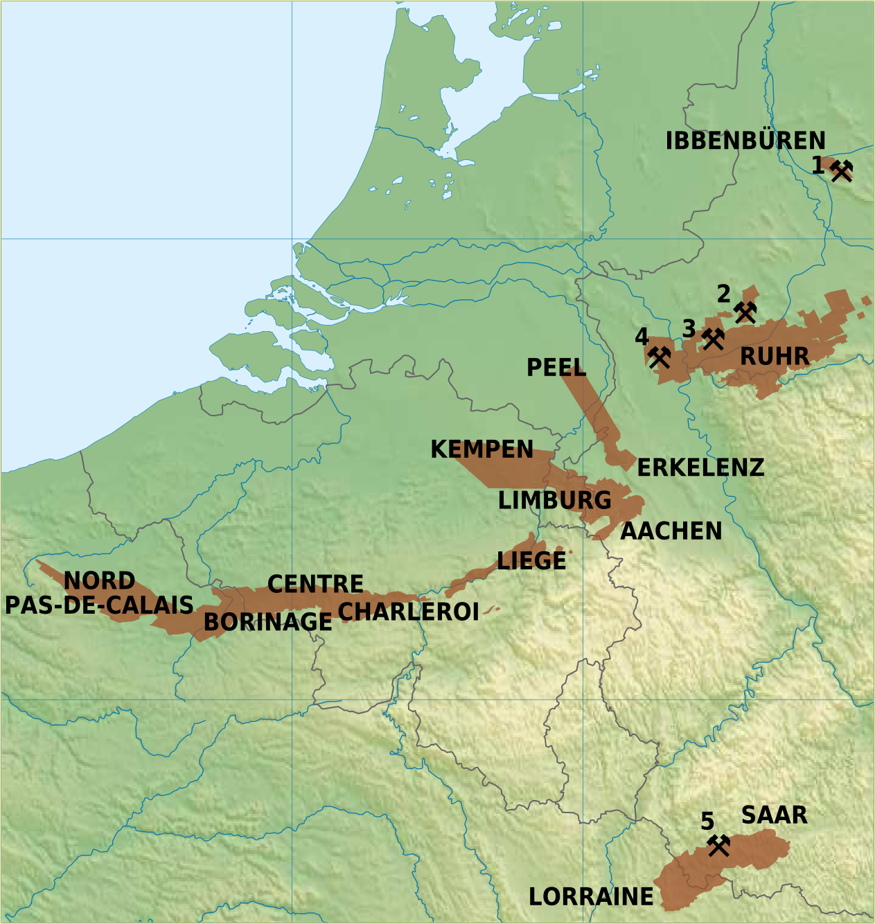
English: Overview map of coal mining areas in Belgium, Netherlands, Germany and Northern France
Nederlands: Overzicht van steenkoolmijngebieden in Belgie, Nederland, Duitsland en Noord-Frankrijk
Deutsch: Uebersichtskarte von Steinkohlrevieren in Belgien, Niederlande, Deutschland und Nord Frankreich
Français : Carte des zones de mines de charbon en Belgique, Pays-Bas, l'Allemagne et Nord de la France |
| 日期 | |
| 來源 | 自己的作品 |
| 作者 | Hans Erren |
Sources:
Germany: Ruhrkohle AG; Geologisches Landesamt Nordrhein-Westfalen, Krefeld; G Fettweis, 1953;  Ramana Rao Nunna, 1960
Netherlands: Rijks Geologische Dienst
Belgium: Kempense Steenkoolmijnen Zolder; Ministere de la Region Wallonne
France: Charbonnages de France

Active Coal Mines in 2012:
1: Bergwerk Ibbenbüren, Ibbenbüren (last coal 17 august 2018, closed 21 december 2018)
2: Zeche Auguste Viktoria, Marl (closed 18 december 2015)
3: Bergwerk Prosper-Haniel, Bottrop (closed 21 december 2018)
4: Bergwerk West, Kamp Lintfort (closed december 2012)
5: Bergwerk Saar, Saarlouis (closed june 2012)
我,本作品的著作權持有者,決定用以下授權條款發佈本作品:
| 此檔案採用創用CC 姓名標示-相同方式分享 3.0 未在地化版本授權條款。 | ||
| ||
| 已新增授權條款標題至此檔案,作為GFDL授權更新的一部份。 |
該地圖是使用通用製圖工具創建的: https://www.generic-mapping-tools.org/ 使用其中一個或多個公有領域浮雕數據集:
|

|
已授權您依據自由軟體基金會發行的無固定段落、封面文字和封底文字GNU自由文件授權條款1.2版或任意後續版本,對本檔進行複製、傳播和/或修改。該協議的副本列在GNU自由文件授權條款中。 |
您可以選擇您需要的授權條款。
授權條款
我,本作品的著作權持有者,決定用以下授權條款發佈本作品:
此檔案採用創用CC 姓名標示-相同方式分享 3.0 未在地化版本授權條款。
- 您可以自由:
- 分享 – 複製、發佈和傳播本作品
- 重新修改 – 創作演繹作品
- 惟需遵照下列條件:
- 姓名標示 – 您必須指名出正確的製作者,和提供授權條款的連結,以及表示是否有對內容上做出變更。您可以用任何合理的方式來行動,但不得以任何方式表明授權條款是對您許可或是由您所使用。
- 相同方式分享 – 若要根據本素材進行再混合、轉換或創作,則必須以與原作相同或相容的授權來發布您的作品。
|
|
已授權您依據自由軟體基金會發行的無固定段落、封面文字和封底文字GNU自由文件授權條款1.2版或任意後續版本,對本檔進行複製、傳播和/或修改。該協議的副本列在GNU自由文件授權條款中。 |
您可以選擇您需要的授權條款。
檔案歷史
點選某个日期/時間檢視對應時刻的檔案。
| 日期/時間 | 縮圖 | 大小 | 使用者 | 備註 | |
|---|---|---|---|---|---|
| 目前 | 2011年1月2日 (日) 22:27 | | 1,263 × 1,334(844 KB) | Hans Erren | border cropped |
| 2011年1月2日 (日) 21:52 |  | 1,291 × 1,363(852 KB) | Hans Erren | {{Information |Description={{en|1=Overview map of coal mining areas in Belgium, Netherlands, Germany and Northern France}} {{nl|1=Overzicht van steenkoolmijngebieden in Belgie, Nederland, Duitsland en Noord-Frankrijk}} {{de|1=Uebersichtskarte von Steinkoh |
檔案用途
下列頁面有用到此檔案:
全域檔案使用狀況
以下其他wiki使用了這個檔案:
- ar.wikipedia.org的使用狀況
- da.wikipedia.org的使用狀況
- de.wikipedia.org的使用狀況
- en.wikipedia.org的使用狀況
- fr.wikipedia.org的使用狀況
- li.wikipedia.org的使用狀況
- nl.wikipedia.org的使用狀況
- sr.wikipedia.org的使用狀況
- trv.wikipedia.org的使用狀況