
File:Iowa rainfall.jpg
預覽大小:800 × 532 像素。 其他解析度:320 × 213 像素 | 640 × 425 像素 | 844 × 561 像素。
原始檔案 (844 × 561 像素,檔案大小:67 KB,MIME 類型:image/jpeg)

|
本图像(或者本分类中的所有图像)用一个特殊的脚本或语言在内部使用了标签或附属的说明文字,这可以转换为语言中立图表。这样它可以用于所有的维基媒体计划,更重要的是,可以用于所有语言版本的维基媒体计划。
|
Most users around the world are not used to inches for precipitations, adding millimeters would be useful.
摘要
| 描述 |
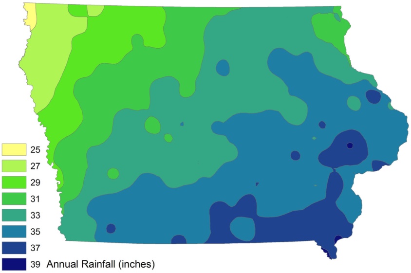
English: Iowa annual fainfall, in inches, created in ESRI ArcMap 9 from ISU-GIS- REF data, utimately from Iowa DNR and state climatologist data. |
| 日期 | 2009年3月31日 (原始上傳日期) |
| 來源 | I created this work entirely by myself. |
| 作者 | Bill Whittaker (talk) |
授權條款
| 此作品已由其作者,英文維基百科的Billwhittaker,釋出至公有領域。此授權條款在全世界均適用。 這可能在某些國家不合法,如果是的話: Billwhittaker授予任何人有權利使用此作品於任何用途,除受法律約束外,不受任何限制。 |
原始上傳日誌
The original description page was here. All following user names refer to en.wikipedia.
| 日期/時間 | 大小 | 使用者 | 備註 |
|---|---|---|---|
| 2009-04-01 02:00 | 844×561× (68886 bytes) | CTF83! | == Summary == {{Information |Description = Iowa annual fainfall, in inches, created in ESRI ArcMap 9 from ISU-GIS- REF data, utimately from Iowa DNR and state climatologist data. |Source = I created this work entirely by myself. |Date |
| 2009-03-31 21:24 | 1500×997× (100075 bytes) | Billwhittaker | {{Information |Description = Iowa annual fainfall, in inches, created in ESRI ArcMap 9 from ISU-GIS- REF data, utimately from Iowa DNR and state climatologist data. |Source = I created this work entirely by myself. |Date = |Auth |
檔案歷史
點選某个日期/時間檢視對應時刻的檔案。
| 日期/時間 | 縮圖 | 大小 | 使用者 | 備註 | |
|---|---|---|---|---|---|
| 目前 | 2017年1月10日 (二) 01:23 | | 844 × 561(67 KB) | BD2412 | Transferred from en.wikipedia |
檔案用途
下列2個頁面有用到此檔案:
全域檔案使用狀況
以下其他wiki使用了這個檔案:
- en.wikipedia.org的使用狀況
- gu.wikipedia.org的使用狀況
- ja.wikipedia.org的使用狀況
- kn.wikipedia.org的使用狀況