
File:Colonisation 1914.png

摘要
| 描述 |
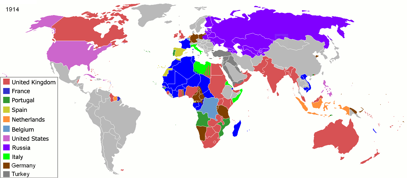
Map of major world powers by year, derived from public domain animated map on wikipedia.
As the orriginal licence of the animation was Public Domain, this image which has been derived from it is too:
|
||||||||||||||||||
| 日期 | |||||||||||||||||||
| 来源 | public domain animated map by ArdadN here | ||||||||||||||||||
| 作者 | ArdadN | ||||||||||||||||||
.jpg)
._LOC_2001620596.jpg)
许可协议

|
此historical map图片可使用矢量图形重新创建为SVG文件。这具有很多好处;更多信息请参见共享资源:待清理媒体。如果存在此图片的SVG格式,请将其上传,然后将此模板替换为
{{vector version available|新图片名称}}。
建议您将SVG命名为“Colonisation 1914.svg”,这样在使用Vector version available(或Vva)模板时就不需要填写新图片名称参数。 |
文件历史
点击某个日期/时间查看对应时刻的文件。
| 日期/时间 | 缩略图 | 大小 | 用户 | 备注 | |
|---|---|---|---|---|---|
| 当前 | 2021年11月8日 (一) 09:07 | | 1,425 × 625(51 KB) | Randomastwritter | jubaland |
| 2020年5月15日 (五) 16:32 |  | 1,425 × 625(51 KB) | Chipmunkdavis | Freeing Belgium and Luxembourg from the Netherlands | |
| 2014年8月3日 (日) 03:05 |  | 1,425 × 625(51 KB) | Alvin Lee | Chinese-Russian boarder | |
| 2011年9月9日 (五) 00:59 |  | 1,425 × 625(50 KB) | SpencerCS | Substantial corrections to Ottoman Empire, Africa, and the Pacific | |
| 2007年3月22日 (四) 10:41 |  | 1,425 × 625(66 KB) | Roke~commonswiki | {{Information |Description=Map of major world powers by year, derived from public domain animated map on wikipedia. {{Maps of world history}} As the orriginal licence of the animation was Public Domain, this image which has been derived from it is too: { |
文件用途
以下页面使用本文件:
全域文件用途
以下其他wiki使用此文件:
- ba.wikipedia.org上的用途
- bn.wikipedia.org上的用途
- bn.wikibooks.org上的用途
- bs.wikipedia.org上的用途
- ca.wikibooks.org上的用途
- cs.wikipedia.org上的用途
- de.wikipedia.org上的用途
- en.wikipedia.org上的用途
- en.wikibooks.org上的用途
- es.wikipedia.org上的用途
- fa.wikipedia.org上的用途
- fi.wikipedia.org上的用途
- fr.wikipedia.org上的用途
- fr.wikiversity.org上的用途
- hu.wikipedia.org上的用途
- hy.wikipedia.org上的用途
- it.wikipedia.org上的用途
- nn.wikipedia.org上的用途
- no.wikipedia.org上的用途
- oc.wikipedia.org上的用途
- pl.wikipedia.org上的用途
- ro.wikipedia.org上的用途
- ru.wikipedia.org上的用途
- sk.wikipedia.org上的用途
- te.wikipedia.org上的用途
- uk.wikipedia.org上的用途